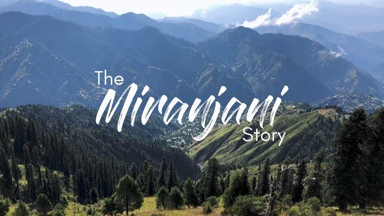
Miranjani stands as a prominent peak within the Galyat Region of Khyber Pakhtunkhwa province in Pakistan. At an elevation of 2,992 meters above sea level, it is the highest point in this region, boasting a stunning panoramic view that attracts adventurers and nature enthusiasts alike. Positioned within the confines of Ayubia National Park, which is approximately 80 kilometers north of the capital city Islamabad, Miranjani offers a refreshing escape into nature with its rich green landscapes and the peaceful ambiance of the western Himalayan range.

The climate of Miranjani is characterized by cool, pleasant weather, which can turn quite chilly as altitude increases. This variation contributes to the diverse experiences it offers throughout the year, with each season painting the mountain in different hues and patterns. The summer months bring a relatively temperate climate ideal for trekking, whereas, during winter, the peak is often blanketed with a layer of crisp, white snow, providing a very different kind of challenge for trekkers.
Accessing Miranjani involves a well-trodden trekking route that begins in the small, scenic town of Nathia Gali. Trekkers embark on this journey, which is famed for being moderately challenging yet highly rewarding, as one traverses through lush forests and over rocky terrains. The summit rewards its visitors with magnificent views of the surrounding Himalayan foothills, making the climb a worthwhile endeavor for those seeking both adventure and natural beauty.
Geography and Access

The Miranjani peak, renowned for its significant elevation and prime location, stands as a prominent hiking destination in the Galyat region, with accessible routes that commence a short distance from Islamabad.
Location and Height
Miranjani is situated within Ayubia National Park, in the Namli Maira area of Abbottabad District, Khyber Pakhtunkhwa. Height-wise, it reaches an impressive elevation of approximately 2,992 meters (9,816 feet), making it the highest point in the Galyat region. The area surrounding Miranjani, commonly associated with Nathia Gali, is characterized by its lush greenery and diverse ecosystem.
Distance From Islamabad
The distance from Islamabad to the foothills of Miranjani is roughly 80 kilometers (50 miles). This translates to approximately an hour’s drive, depending on the mode of transportation and the chosen route. For those keen on hiking, the trail to Miranjani begins near Nathia Gali, effectively merging accessibility with the adventure of scaling the region’s tallest peak.
Hiking to Miranjani

Hiking to Miranjani offers a chance to reach the summit of one of the highest peaks in the Galyat region, showcasing incredible views and a fulfilling trekking experience.
Hiking Trail Details
Distance: The trek to Miranjani Top is approximately 10 km round trip, taking trekkers from the base to the peak which stands at an elevation of 2,992 meters (9,816 feet).
Time Required: Regular hikers usually reach the summit within 3 to 3.5 hours, while those less accustomed to such treks may take up to 5 to 6 hours. The time varies depending on one’s pace and frequency of breaks.
Tips:
- Water: Travelers should bring at least 1.5 liters of water, as there are no water sources along the hike.
- Snacks: Energy-boosting snacks are advised to maintain stamina throughout the trek.
- Footwear and Clothing: Wear sturdy hiking shoes and appropriate clothing to suit the weather conditions.
- Sun Protection: Sunscreen and a hat are recommended to protect against sun exposure.
Trekking Map and Starting Point
Start Point: The trek begins at the Government Rest House in Nathia Gali, a common starting point for many hikers aiming to reach Miranjani Top.
Map: A trekking map is often highly beneficial for orientation and navigation purposes, as it outlines the trail and significant landmarks.
| Waypoint | Description |
|---|---|
| Government Rest House | Common starting location for the trek. |
| Miranjani Track Intersection | Checkpoint for the different trail routes. |
| Miranjani Top | End goal, the summit offering panoramic views. |
Travelers can usually find maps at local tourist offices or online forums dedicated to hiking in Pakistan. It’s critical to have a clear understanding of the path before commencing the trek.
Climate and Best Time to Visit

Climate
The climate of Miranjani varies prominently with the seasons. During the winter months, from December to February, temperatures frequently fall below freezing. One can expect snowfall, especially at higher altitudes, with daytime temperatures ranging between 0°C to 10°C (32°F to 50°F) and even colder nights.
In contrast, the summer climate (June to August) is mild and inviting. Average temperatures hover between 20°C to 30°C (68°F to 86°F). However, evenings can cool down, particularly after rain showers, making it advisable to bring jackets and rainwear.
Best Time to Visit
Visitors seeking the best weather conditions for outdoor activities should consider the following guidance:
- Summer: Optimal for hiking and outdoor exploration. The mild temperatures provide a pleasant atmosphere.
- Winter: Ideal for those looking for winter sports or to experience the serene beauty of snow-covered landscapes. It should be noted that proper winter gear is essential for comfort and safety.
Tips for Visitors:
- Summer: Don’t forget to bring sunscreen and a hat to protect against the strong afternoon sun.
- Winter: Essential items include a sturdy pair of boots, warm clothing layers, and a reliable raincoat to withstand the colder and wetter conditions.
When planning a trip, afternoons are particularly recommended as the sun is less intense, making for a more comfortable and enjoyable visit. Moreover, those who prefer a lush natural environment should consider August, when the area’s flora is in full bloom. Regardless of the season, Miranjani offers a unique experience for trekkers and nature enthusiasts alike.
Conservation and Tourism

In Pakistan, the Miranjani Peak serves as a prime example of natural splendor, demanding efforts for conservation while promoting sustainable tourism. Known as the highest peak in the Galiyat region, Miranjani stands approximately 2,992 meters above sea level and offers stunning vistas of the surrounding landscape, including the Margalla Hills and Abbottabad.
As tourism increases, the pressure on local ecosystems also rises. Authorities have begun implementing measures to ensure that the natural beauty of Miranjani and its surroundings is preserved. This includes managing foot traffic on trails to mitigate soil erosion and protecting indigenous flora and fauna from the disturbances that come with frequent human activity. Initiatives for reducing waste and promoting environmental education among visitors are considered vital for conservation efforts.
The challenge remains to balance the influx of tourists with environmental sustainability. This involves cooperation between:
- Local communities
- Environmental organizations
- Government bodies
Their collective mission is to develop strategies that protect Miranjani’s integrity while also welcoming the economic benefits of tourism. This collaborative approach aims to align with the SDGs to ensure that the peak remains a source of natural inspiration and adventure for generations to come.